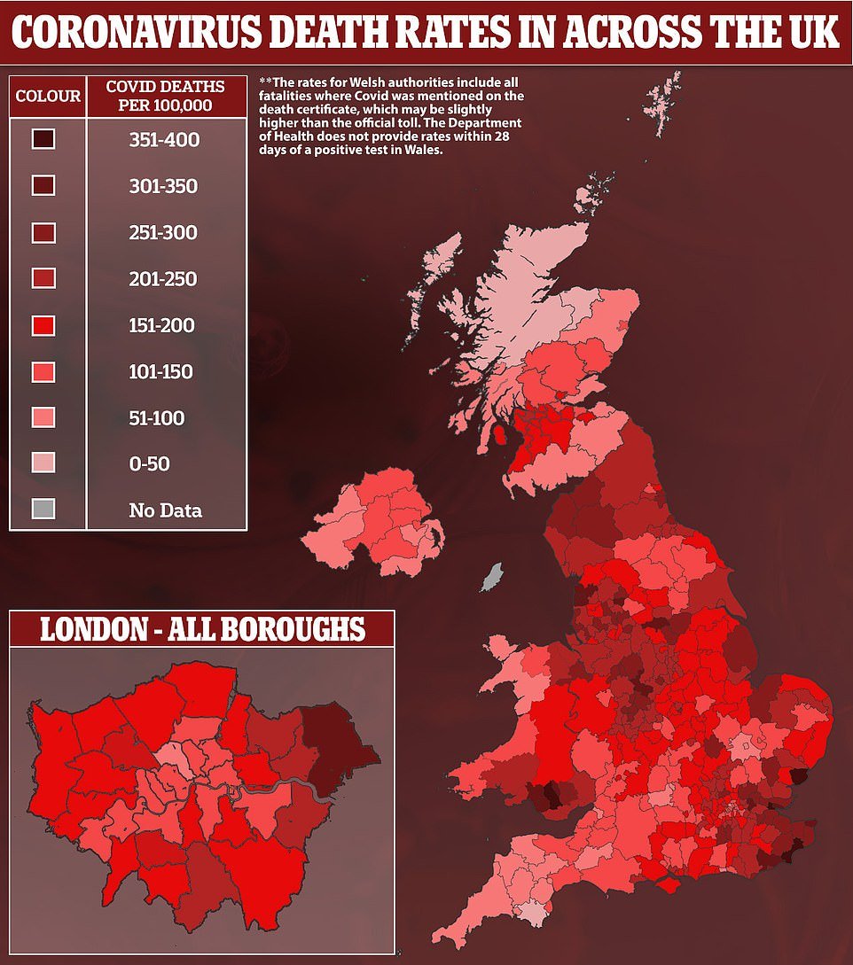
Coronavirus death rates are up to 30 times higher in the worst-hit parts of Essex than rural regions of Scotland, official statistics have revealed.
Data from the Government’s Covid dashboard show there have been 393 confirmed virus victims per 100,000 people in Castle Point, the highest of any authority in the UK. In second worst-hit Tendring, the rate is 381. These figures are the equivalent of almost 0.4 per cent of the population in each borough.
According to the figures — which look at deaths in which a person died within 28 days of a positive Covid test —Folkestone and Hythe, in Kent, has seen a similarly high number of victims at 364 per 100,000, the equivalent of more than 0.36 per cent of its population.
By contrast, the local authorities with the lowest Covid death rates were rural areas in the Scottish Highlands and Islands, with the rate as low as 13.5 on the Orkney Islands. The figure for England as a whole has been 194 per 100,000 (almost 0.2 per cent) and the UK’s is slightly lower at 186.
The figures offer yet more proof that Covid is much deadlier than flu, which kills around 0.1 per cent of everyone infected. Not everyone in England has even had coronavirus, meaning the true infection fatality rate (IFR) of the illness will be much higher. No10’s top scientists believe the overall IFR is around 0.5 per cent but the disease is a lot deadlier to the elderly.
The fact all three of the most badly-hit areas are in the South East of England is because the region bore the brunt of the second wave of the crisis this winter. An outbreak of the highly-infectious and more deadly B117 variant that emerged in Kent sparked a wave of hospital admissions and fatalities that surpassed the peak last spring.
MailOnline’s analysis of the Department of Health figures reveal Castle Point had a Covid death rate of just 91 per 100,000 people, Tendring 92 and Folkestone and Hythe 122, at the start of September, before the new variant took off, revealing the scale of the winter wave.
Rounding out the five places with the highest Covid death rates were Rother in East Sussex (343 per 100,000) and East Staffordshire (337).
Areas in Lancashire, London and Yorkshire also saw more than 0.3 per cent of their residents killed by the virus in the last 12 months.
Nearly 0.4 per cent of the populations in two Essex districts have been wiped out by coronavirus, according to shocking Government Covid dashboard figures

The Covid death rate for England as a whole has been 194 per 100,000 (almost 0.2 per cent) and the UK’s is slightly lower at 186

Five Welsh local authorities also recorded rates of over 300 Covid deaths per 100,000 population, the figures show, but those figures look at all fatalities in which the virus was mentioned on the death certificate.
They are: Rhondda Cynon Taf (351 per 100,000), Bridgend (333), Merthyr Tydfil (333), Neath Port Talbot (318) and Blaenau Gwent (301).
These rates are naturally slightly higher because they includes all deaths where Covid was suspected of being a contributing factor without the patient actually being diagnosed with the virus.
For example, the UK’s overall death toll within 28 days of a positive test is 124,566 but when this is extended to all fatalities suspected of being Covid it rises to 140,062.
The latter dataset is crucial for trying to estimate the number of deaths during the first wave of the epidemic last spring, when testing was limited. The Department of Health does not currently provide a breakdown of deaths in Wales within 28 days of a positive Covid test.
Meanwhile, the dashboard data revealed the Orkney Islands in Scotland have recorded just three Covid deaths within 28 days of a test since the pandemic began, giving it the UK’s lowest fatality rate of 13.5 per 100,000.
Just a handful of deaths in Comhairle nan Eilean Siar, on the Isle of Lewis, gave it a rate of 26.2. Moray (30.3), the Shetland Islands (39.3) and the Highlands (40.3) round out the bottom five.
Covid, like all respiratory viruses, thrives in densely populated places where there is lots of social contact which makes it easier for it to spread between people. In rural areas where residents live far apart and there are less pubs, restaurants and shops, the virus finds it more difficult to transmit.
According to global data from the Johns Hopkins University Coronavirus Tracker, the UK has suffered the third worst death rate, which it estimates to be 181 fatalities per 100,000 people. The Department of Health claims the rate is actually slightly higher at 186.5.
Experts have said Britain’s dense population is thought to have been one of the driving factors behind it being one of the worst-hit countries, as well as London’s status as Europe’s main transport hub.
However, a major report last week suggested countries badly hit by the pandemic were also home to the highest levels of obesity.
The World Obesity Federation research found Covid deaths have been 10 times higher in countries where at least half of adults are overweight, and they have accounted for a staggering 90 per cent of global deaths.
Critics of the report said the correlation did not prove causation, adding that although Western countries tend to be fatter, they were also less prepared for pandemics than nations in Asia that have battled several viral outbreaks in recent years.
Britain yesterday recorded just 65 more Covid deaths, which was the lowest since October, before the second wave gathered steam. Broken down, 109,664 have been in England, 7,422 in Scotland, 5,403 in Wales and 2,077 in Northern Ireland.
Deaths are expected to remain squashed now that almost 24million of the most vulnerable Brits have had their first Covid vaccine. About a million have had both injections.
The Oxford University/AstraZeneca and Pfizer/BioNTech jabs have been shown to be more than 80 per cent effective at preventing people from being hospitalised with Covid, even after just one shot.
| LOWER TIER LOCAL AUTHORITY | CUMULATIVE COVID DEATH RATE (8 MAR) | CUMULATIVE COVID DEATH RATE (1 SEP) | DEATH RATE DIFFERENCE (2ND WAVE FIGURE) | PERCENTAGE DIFFERENCE BETWEEN WAVES |
|---|---|---|---|---|
| Rother | 342.4 | 38.5 | 303.9 | 689.35% |
| Castle Point | 393.9 | 90.7 | 303.2 | 234.29% |
| Tendring | 382.1 | 92.1 | 290 | 214.88% |
| Hastings | 267.6 | 8.6 | 259 | 2911.63% |
| Burnley | 305.9 | 51.7 | 254.2 | 391.68% |
| Eastbourne | 287.2 | 44.3 | 242.9 | 448.31% |
| Folkestone and Hythe | 364.6 | 122.1 | 242.5 | 98.61% |
| East Staffordshire | 338.2 | 101.9 | 236.3 | 131.89% |
| Havering | 317.1 | 83.2 | 233.9 | 181.13% |
| Southend-on-Sea | 317.8 | 89 | 228.8 | 157.08% |
| East Lindsey | 263.2 | 36.7 | 226.5 | 517.17% |
| Thanet | 305.8 | 81.7 | 224.1 | 174.30% |
| Barnsley | 312.7 | 90.7 | 222 | 144.76% |
| Swale | 277.8 | 60.6 | 217.2 | 258.42% |
| Wyre | 308.7 | 92.8 | 215.9 | 132.65% |
| Blackpool | 307.6 | 93.2 | 214.4 | 130.04% |
| Fylde | 315.7 | 101.5 | 214.2 | 111.03% |
| Stoke-on-Trent | 269.1 | 58.9 | 210.2 | 256.88% |
| Blackburn with Darwen | 267.9 | 59.5 | 208.4 | 250.25% |
| Mansfield | 246.1 | 42.1 | 204 | 384.56% |
| Sandwell | 300.2 | 96.5 | 203.7 | 111.09% |
| Staffordshire Moorlands | 271.2 | 69.1 | 202.1 | 192.47% |
| Medway | 262.4 | 61.4 | 201 | 227.36% |
| Ribble Valley | 236.5 | 36.1 | 200.4 | 455.12% |
| Bolsover | 244.5 | 44.7 | 199.8 | 346.98% |
| Rochford | 291.9 | 92.7 | 199.2 | 114.89% |
| Braintree | 264.7 | 67.5 | 197.2 | 192.15% |
| Boston | 242.3 | 45.6 | 196.7 | 331.36% |
| Sefton | 276.8 | 80.3 | 196.5 | 144.71% |
| Canterbury | 259.4 | 67.1 | 192.3 | 186.59% |
| Pendle | 257.3 | 65.1 | 192.2 | 195.24% |
| Carlisle | 285.2 | 93.9 | 191.3 | 103.73% |
| Oadby and Wigston | 277.1 | 85.9 | 191.2 | 122.58% |
| Allerdale | 263.9 | 73.6 | 190.3 | 158.56% |
| Doncaster | 260.7 | 70.5 | 190.2 | 169.79% |
| Eden | 253.5 | 63.8 | 189.7 | 197.34% |
| Great Yarmouth | 232.5 | 43.3 | 189.2 | 336.95% |
| Hyndburn | 246.8 | 59.2 | 187.6 | 216.89% |
| Bournemouth, Christchurch and Poole | 216 | 28.8 | 187.2 | 550.00% |
| Cannock Chase | 254.1 | 67.5 | 186.6 | 176.44% |
| Wigan | 279.6 | 94.3 | 185.3 | 96.50% |
| Broadland | 234 | 48.9 | 185.1 | 278.53% |
| Gravesham | 266.5 | 82.3 | 184.2 | 123.82% |
| Walsall | 288.6 | 105.1 | 183.5 | 74.60% |
| South Bucks | 238.5 | 55.4 | 183.1 | 230.51% |
| Knowsley | 270.4 | 88.2 | 182.2 | 106.58% |
| King’s Lynn and West Norfolk | 263.6 | 82.6 | 181 | 119.13% |
| Brentwood | 272.7 | 92.2 | 180.5 | 95.77% |
| Surrey Heath | 241.9 | 61.6 | 180.3 | 192.69% |
| South Tyneside | 273.6 | 93.4 | 180.2 | 92.93% |
| Wolverhampton | 271.5 | 91.9 | 179.6 | 95.43% |
| Bedford | 277.6 | 98.1 | 179.5 | 82.98% |
| Newcastle-under-Lyme | 265.8 | 87.3 | 178.5 | 104.47% |
| Thurrock | 249.5 | 72.3 | 177.2 | 145.09% |
| Maidstone | 219.4 | 43.1 | 176.3 | 309.05% |
| Rochdale | 272 | 97.6 | 174.4 | 78.69% |
| Basildon | 262.3 | 90.3 | 172 | 90.48% |
| Rotherham | 273.5 | 101.7 | 171.8 | 68.93% |
| Amber Valley | 235.7 | 64 | 171.7 | 168.28% |
| Sunderland | 268.3 | 97.2 | 171.1 | 76.03% |
| Dover | 266.7 | 95.7 | 171 | 78.68% |
| Hartlepool | 265.8 | 95 | 170.8 | 79.79% |
| Erewash | 237.5 | 66.7 | 170.8 | 156.07% |
| Babergh | 226 | 55.4 | 170.6 | 207.94% |
| Lichfield | 258.7 | 89.7 | 169 | 88.41% |
| Kingston upon Hull, City of | 239.1 | 70.1 | 169 | 141.08% |
| Stafford | 236 | 67.7 | 168.3 | 148.60% |
| Tamworth | 245.1 | 76.9 | 168.2 | 118.73% |
| Chichester | 199.8 | 32.2 | 167.6 | 420.50% |
| Copeland | 243.5 | 76.3 | 167.2 | 119.13% |
| Maldon | 209.5 | 43.1 | 166.4 | 286.08% |
| Epping Forest | 279.4 | 113.1 | 166.3 | 47.04% |
| Derby | 253.8 | 88.2 | 165.6 | 87.76% |
| Mole Valley | 257.9 | 92.8 | 165.1 | 77.91% |
| Darlington | 230.3 | 65.5 | 164.8 | 151.60% |
| Redbridge | 235.2 | 70.8 | 164.4 | 132.20% |
| Fareham | 221.1 | 56.8 | 164.3 | 189.26% |
| Ashfield | 236.9 | 72.7 | 164.2 | 125.86% |
| Barking and Dagenham | 214.2 | 50.7 | 163.5 | 222.49% |
| Three Rivers | 245.4 | 82.5 | 162.9 | 97.45% |
| Breckland | 212.2 | 49.3 | 162.9 | 230.43% |
| Reigate and Banstead | 254.1 | 91.4 | 162.7 | 78.01% |
| St. Helens | 242 | 80.3 | 161.7 | 101.37% |
| Tameside | 282.6 | 121 | 161.6 | 33.55% |
| Stockton-on-Tees | 221.4 | 60.3 | 161.1 | 167.16% |
| West Lindsey | 177.7 | 16.7 | 161 | 864.07% |
| Havant | 219.5 | 58.6 | 160.9 | 174.57% |
| Tandridge | 240.6 | 80.6 | 160 | 98.51% |
| Oldham | 248 | 89 | 159 | 78.65% |
| Broxtowe | 226.3 | 67.5 | 158.8 | 135.26% |
| Liverpool | 233.5 | 74.9 | 158.6 | 111.75% |
| Arun | 184.1 | 25.5 | 158.6 | 521.96% |
| Rossendale | 205.6 | 47.6 | 158 | 231.93% |
| Cheshire West and Chester | 247.8 | 90.9 | 156.9 | 72.61% |
| Gedling | 211.2 | 55.1 | 156.1 | 183.30% |
| Wealden | 203.1 | 47.1 | 156 | 231.21% |
| High Peak | 238.5 | 84.2 | 154.3 | 83.25% |
| Melton | 187.5 | 33.2 | 154.3 | 364.76% |
| Lincoln | 185.3 | 31.2 | 154.1 | 393.91% |
| Epsom and Ewell | 225.7 | 71.9 | 153.8 | 113.91% |
| Barrow-in-Furness | 234.2 | 80.5 | 153.7 | 90.93% |
| Dudley | 231.3 | 77.7 | 153.6 | 97.68% |
| Wirral | 246.6 | 93.8 | 152.8 | 62.90% |
| North Ayrshire | 199.6 | 46.8 | 152.8 | 226.50% |
| Bury | 259.7 | 107.3 | 152.4 | 42.03% |
| Warrington | 225.2 | 73.3 | 151.9 | 107.23% |
| North Kesteven | 182.2 | 30.8 | 151.4 | 391.56% |
| Solihull | 240.3 | 89.7 | 150.6 | 67.89% |
| Renfrewshire | 202.7 | 52.5 | 150.2 | 186.10% |
| Lancaster | 193.8 | 43.8 | 150 | 242.47% |
| Bexley | 223.5 | 74.5 | 149 | 100.00% |
| Redditch | 215.8 | 66.9 | 148.9 | 122.57% |
| South Kesteven | 184.7 | 35.8 | 148.9 | 315.92% |
| Chelmsford | 220.9 | 72.9 | 148 | 103.02% |
| North Hertfordshire | 205.1 | 57.6 | 147.5 | 156.08% |
| Dartford | 237.1 | 89.7 | 147.4 | 64.33% |
| Rushmoor | 205.1 | 58.1 | 147 | 153.01% |
| Colchester | 194.1 | 48.3 | 145.8 | 201.86% |
| Hertsmere | 276.4 | 130.6 | 145.8 | 11.64% |
| Sevenoaks | 203.7 | 58 | 145.7 | 151.21% |
| Ipswich | 216.9 | 71.6 | 145.3 | 102.93% |
| South Staffordshire | 213.5 | 68.5 | 145 | 111.68% |
| North West Leicestershire | 197.9 | 53.1 | 144.8 | 172.69% |
| Dacorum | 204.8 | 60.7 | 144.1 | 137.40% |
| Broxbourne | 200.5 | 56.5 | 144 | 154.87% |
| Bolton | 246.9 | 103.6 | 143.3 | 38.32% |
| Birmingham | 227.3 | 84.1 | 143.2 | 70.27% |
| Wyre Forest | 230 | 86.9 | 143.1 | 64.67% |
| North Lanarkshire | 192.2 | 49.2 | 143 | 190.65% |
| East Riding of Yorkshire | 211.9 | 69.5 | 142.4 | 104.89% |
| Ashford | 252.2 | 110 | 142.2 | 29.27% |
| Northumberland | 207.8 | 65.7 | 142.1 | 116.29% |
| Watford | 242.3 | 100.4 | 141.9 | 41.33% |
| Norwich | 150.8 | 9.2 | 141.6 | 1439.13% |
| Lewes | 207.2 | 65.8 | 141.4 | 114.89% |
| Sutton | 207.4 | 67.4 | 140 | 107.72% |
| North Tyneside | 192.4 | 52.4 | 140 | 167.18% |
| Windsor and Maidenhead | 188.2 | 48.2 | 140 | 190.46% |
| Luton | 226.7 | 86.8 | 139.9 | 61.18% |
| North East Lincolnshire | 161.1 | 21.3 | 139.8 | 556.34% |
| East Ayrshire | 181.1 | 41.8 | 139.3 | 233.25% |
| North East Derbyshire | 241.5 | 102.5 | 139 | 35.61% |
| Preston | 213.8 | 74.8 | 139 | 85.83% |
| County Durham | 232.2 | 93.8 | 138.4 | 47.55% |
| Redcar and Cleveland | 205.6 | 67.8 | 137.8 | 103.24% |
| South Holland | 189.4 | 51.6 | 137.8 | 167.05% |
| Blaby | 197 | 60.1 | 136.9 | 127.79% |
| Wakefield | 210.4 | 73.8 | 136.6 | 85.09% |
| West Lancashire | 226.6 | 90.1 | 136.5 | 51.50% |
| Harlow | 213.6 | 78.1 | 135.5 | 73.50% |
| Derbyshire Dales | 201.9 | 66.4 | 135.5 | 104.07% |
| North Norfolk | 178.4 | 42.9 | 135.5 | 215.85% |
| Chesterfield | 196.4 | 61 | 135.4 | 121.97% |
| South Lanarkshire | 192.8 | 57.7 | 135.1 | 134.14% |
| Bassetlaw | 183 | 48.5 | 134.5 | 177.32% |
| Gosport | 183.9 | 49.5 | 134.4 | 171.52% |
| Waverley | 192.4 | 59.4 | 133 | 123.91% |
| Leicester | 208.9 | 77.4 | 131.5 | 69.90% |
| Wycombe | 168.7 | 37.9 | 130.8 | 245.12% |
| Milton Keynes | 169.6 | 39.3 | 130.3 | 231.55% |
| North Warwickshire | 234.4 | 104.2 | 130.2 | 24.95% |
| Rushcliffe | 180.4 | 50.3 | 130.1 | 158.65% |
| Slough | 187.9 | 58.2 | 129.7 | 122.85% |
| South Derbyshire | 203.2 | 73.7 | 129.5 | 75.71% |
| Hounslow | 197.4 | 68.9 | 128.5 | 86.50% |
| Worthing | 171.8 | 43.4 | 128.4 | 195.85% |
| St Albans | 203.4 | 75.4 | 128 | 69.76% |
| South Ayrshire | 178.5 | 50.6 | 127.9 | 152.77% |
| Portsmouth | 162.9 | 35.4 | 127.5 | 260.17% |
| Welwyn Hatfield | 190.2 | 63.4 | 126.8 | 100.00% |
| Nottingham | 177.5 | 51.1 | 126.4 | 147.36% |
| Tunbridge Wells | 170.1 | 43.8 | 126.3 | 188.36% |
| Bromsgrove | 243.3 | 117.1 | 126.2 | 7.77% |
| Hillingdon | 194.2 | 69.1 | 125.1 | 81.04% |
| East Suffolk | 197.2 | 72.2 | 125 | 73.13% |
| Fenland | 194.4 | 69.7 | 124.7 | 78.91% |
| Tonbridge and Malling | 155.9 | 31.8 | 124.1 | 290.25% |
| South Lakeland | 203.6 | 80.9 | 122.7 | 51.67% |
| Isle of Wight | 174.2 | 51.5 | 122.7 | 138.25% |
| North Lincolnshire | 174.1 | 51.7 | 122.4 | 136.75% |
| Kirklees | 180.5 | 58.2 | 122.3 | 110.14% |
| Newark and Sherwood | 162.6 | 41.7 | 120.9 | 189.93% |
| Scarborough | 179.3 | 58.8 | 120.5 | 104.93% |
| Halton | 200.9 | 80.4 | 120.5 | 49.88% |
| Mendip | 137.6 | 17.3 | 120.3 | 595.38% |
| South Ribble | 175.1 | 55.1 | 120 | 117.79% |
| South Norfolk | 147.6 | 27.7 | 119.9 | 332.85% |
| Northampton | 218.2 | 98.4 | 119.8 | 21.75% |
| Peterborough | 163.7 | 44 | 119.7 | 172.05% |
| Spelthorne | 188.3 | 69.1 | 119.2 | 72.50% |
| Middlesbrough | 237.6 | 118.5 | 119.1 | 0.51% |
| Wychavon | 181.6 | 62.6 | 119 | 90.10% |
| Aylesbury Vale | 161.9 | 43.3 | 118.6 | 173.90% |
| Sheffield | 188.9 | 70.4 | 118.5 | 68.32% |
| Hart | 155.6 | 37.1 | 118.5 | 219.41% |
| Chorley | 187.8 | 69.4 | 118.4 | 70.61% |
| East Dunbartonshire | 178.6 | 60.8 | 117.8 | 93.75% |
| Rutland | 150.3 | 32.6 | 117.7 | 261.04% |
| Elmbridge | 178.4 | 60.7 | 117.7 | 93.90% |
| Charnwood | 164.1 | 46.8 | 117.3 | 150.64% |
| East Renfrewshire | 171.7 | 54.4 | 117.3 | 115.63% |
| Stockport | 211 | 94.4 | 116.6 | 23.52% |
| Mid and East Antrim | 147.9 | 31.6 | 116.3 | 268.04% |
| Salford | 214 | 97.7 | 116.3 | 19.04% |
| Gateshead | 207.9 | 92.1 | 115.8 | 25.73% |
| Central Bedfordshire | 195.4 | 79.7 | 115.7 | 45.17% |
| Worcester | 166 | 50.4 | 115.6 | 129.37% |
| East Northamptonshire | 194.7 | 79.3 | 115.4 | 45.52% |
| Glasgow City | 175.5 | 60.2 | 115.3 | 91.53% |
| New Forest | 159.9 | 45.5 | 114.4 | 151.43% |
| Newham | 173.9 | 59.8 | 114.1 | 90.80% |
| Bradford | 188 | 74.5 | 113.5 | 52.35% |
| Croydon | 206.1 | 93.6 | 112.5 | 20.19% |
| Manchester | 178.3 | 66 | 112.3 | 70.15% |
| Crawley | 170.8 | 58.7 | 112.1 | 90.97% |
| Mid Ulster | 131.3 | 20.2 | 111.1 | 450.00% |
| Shropshire | 169.3 | 58.5 | 110.8 | 89.40% |
| Merton | 191.2 | 80.4 | 110.8 | 37.81% |
| Perth and Kinross | 140.2 | 30.3 | 109.9 | 262.71% |
| Corby | 167.5 | 58.2 | 109.3 | 87.80% |
| Dorset | 135.3 | 26.4 | 108.9 | 312.50% |
| Mid Suffolk | 170.4 | 61.6 | 108.8 | 76.62% |
| Cheshire East | 204.1 | 95.5 | 108.6 | 13.72% |
| Malvern Hills | 155 | 47 | 108 | 129.79% |
| Warwick | 152.3 | 44.5 | 107.8 | 142.25% |
| Woking | 162.7 | 55.6 | 107.1 | 92.63% |
| Bromley | 181.1 | 74.3 | 106.8 | 43.74% |
| Barnet | 185.7 | 79.3 | 106.4 | 34.17% |
| Harborough | 152.4 | 46.9 | 105.5 | 124.95% |
| Somerset West and Taunton | 128.9 | 23.9 | 105 | 339.33% |
| Clackmannanshire | 164.9 | 60.1 | 104.8 | 74.38% |
| Basingstoke and Deane | 162 | 57.2 | 104.8 | 83.22% |
| Mid Sussex | 175.5 | 70.9 | 104.6 | 47.53% |
| Kettering | 185.7 | 83.5 | 102.2 | 22.40% |
| Armagh City, Banbridge and Craigavon | 129 | 27.3 | 101.7 | 272.53% |
| Enfield | 174.4 | 72.8 | 101.6 | 39.56% |
| Trafford | 187.9 | 86.4 | 101.5 | 17.48% |
| East Hampshire | 145.5 | 45 | 100.5 | 123.33% |
| Ealing | 175.5 | 75.2 | 100.3 | 33.38% |
| Nuneaton and Bedworth | 211.7 | 111.6 | 100.1 | -10.30% |
| Hinckley and Bosworth | 169.7 | 69.8 | 99.9 | 43.12% |
| Kingston upon Thames | 164.5 | 64.8 | 99.7 | 53.86% |
| Waltham Forest | 168.6 | 69 | 99.6 | 44.35% |
| Stevenage | 156 | 56.9 | 99.1 | 74.17% |
| West Dunbartonshire | 177.7 | 78.7 | 99 | 25.79% |
| Leeds | 156.6 | 57.9 | 98.7 | 70.47% |
| East Devon | 115.5 | 17.1 | 98.4 | 475.44% |
| Test Valley | 152.2 | 53.9 | 98.3 | 82.37% |
| East Hertfordshire | 146.2 | 48.7 | 97.5 | 100.21% |
| Stratford-on-Avon | 190.6 | 93.8 | 96.8 | 3.20% |
| Telford and Wrekin | 139.6 | 42.8 | 96.8 | 126.17% |
| Wellingborough | 165.6 | 69 | 96.6 | 40.00% |
| Falkirk | 143 | 46.6 | 96.4 | 106.87% |
| West Lothian | 132.2 | 36.6 | 95.6 | 161.20% |
| Inverclyde | 177.4 | 82.3 | 95.1 | 15.55% |
| Calderdale | 143.3 | 48.7 | 94.6 | 94.25% |
| Rugby | 136.8 | 42.2 | 94.6 | 124.17% |
| Cotswold | 153.6 | 59 | 94.6 | 60.34% |
| Antrim and Newtownabbey | 136.6 | 42.5 | 94.1 | 121.41% |
| Runnymede | 154.3 | 60.4 | 93.9 | 55.46% |
| Chiltern | 160.3 | 66.6 | 93.7 | 40.69% |
| York | 143.4 | 50.3 | 93.1 | 85.09% |
| Brent | 210.4 | 117.7 | 92.7 | -21.24% |
| Herefordshire, County of | 143.2 | 50.8 | 92.4 | 81.89% |
| Stirling | 117.8 | 26.5 | 91.3 | 244.53% |
| Craven | 155.8 | 64.8 | 91 | 40.43% |
| Reading | 159.5 | 68.6 | 90.9 | 32.51% |
| Lewisham | 163.2 | 72.6 | 90.6 | 24.79% |
| Forest of Dean | 131.4 | 41.5 | 89.9 | 116.63% |
| Bath and North East Somerset | 112.3 | 22.8 | 89.5 | 292.54% |
| North Somerset | 140.9 | 51.6 | 89.3 | 73.06% |
| Brighton and Hove | 124.4 | 35.1 | 89.3 | 154.42% |
| Daventry | 154.7 | 66.3 | 88.4 | 33.33% |
| Guildford | 126.2 | 38.3 | 87.9 | 129.50% |
| Gloucester | 158 | 70.5 | 87.5 | 24.11% |
| Hambleton | 135.4 | 48 | 87.4 | 82.08% |
| Cheltenham | 159.9 | 73.1 | 86.8 | 18.74% |
| Newcastle upon Tyne | 142 | 56.1 | 85.9 | 53.12% |
| Bracknell Forest | 128.9 | 43.2 | 85.7 | 98.38% |
| Hackney and City of London | 143 | 57.4 | 85.6 | 49.13% |
| Wiltshire | 127.4 | 42 | 85.4 | 103.33% |
| Sedgemoor | 123.4 | 38.2 | 85.2 | 123.04% |
| Coventry | 140.5 | 55.4 | 85.1 | 53.61% |
| Winchester | 146.6 | 61.7 | 84.9 | 37.60% |
| Causeway Coast and Glens | 111.2 | 26.9 | 84.3 | 213.38% |
| Greenwich | 145.2 | 61.1 | 84.1 | 37.64% |
| Tewkesbury | 143.1 | 60 | 83.1 | 38.50% |
| South Gloucestershire | 123.8 | 41.4 | 82.4 | 99.03% |
| Horsham | 139.8 | 57.7 | 82.1 | 42.29% |
| Selby | 117 | 35.3 | 81.7 | 131.44% |
| Stroud | 136.7 | 55 | 81.7 | 48.55% |
| Tower Hamlets | 118.6 | 37.3 | 81.3 | 117.96% |
| Harrow | 197.5 | 117.1 | 80.4 | -31.34% |
| Eastleigh | 129.5 | 49.4 | 80.1 | 62.15% |
| Uttlesford | 134.7 | 54.8 | 79.9 | 45.80% |
| Cherwell | 124.9 | 45.2 | 79.7 | 76.33% |
| Wokingham | 132.1 | 52.6 | 79.5 | 51.14% |
| Wandsworth | 133.2 | 53.7 | 79.5 | 48.04% |
| Lambeth | 152.7 | 74.2 | 78.5 | 5.80% |
| Richmond upon Thames | 132.8 | 56.1 | 76.7 | 36.72% |
| Torbay | 110.8 | 34.5 | 76.3 | 121.16% |
| Southampton | 123.2 | 48.7 | 74.5 | 52.98% |
| Richmondshire | 143.3 | 68.9 | 74.4 | 7.98% |
| Ryedale | 117.4 | 43.3 | 74.1 | 71.13% |
| Angus | 113.6 | 39.6 | 74 | 86.87% |
| Derry City and Strabane | 87.9 | 13.9 | 74 | 432.37% |
| Islington | 119.6 | 45.8 | 73.8 | 61.14% |
| Dundee City | 149.3 | 75.7 | 73.6 | -2.77% |
| Haringey | 135.9 | 62.9 | 73 | 16.06% |
| Huntingdonshire | 134.3 | 61.8 | 72.5 | 17.31% |
| South Northamptonshire | 118.5 | 46.6 | 71.9 | 54.29% |
| South Cambridgeshire | 95.5 | 23.9 | 71.6 | 199.58% |
| Newry, Mourne and Down | 89.9 | 18.7 | 71.2 | 280.75% |
| Kensington and Chelsea | 130 | 58.9 | 71.1 | 20.71% |
| Teignbridge | 88 | 17.1 | 70.9 | 314.62% |
| Swindon | 117.9 | 47.3 | 70.6 | 49.26% |
| West Suffolk | 108.9 | 38.5 | 70.4 | 82.86% |
| Midlothian | 164.4 | 94.1 | 70.3 | -25.29% |
| Bristol, City of | 99.9 | 30.4 | 69.5 | 128.62% |
| Mid Devon | 86.3 | 17 | 69.3 | 307.65% |
| South Oxfordshire | 114 | 45.1 | 68.9 | 52.77% |
| Aberdeen City | 101.9 | 34.1 | 67.8 | 98.83% |
| South Somerset | 87.9 | 20.2 | 67.7 | 235.15% |
| East Cambridgeshire | 102.4 | 36.7 | 65.7 | 79.02% |
| Fife | 99.3 | 34 | 65.3 | 92.06% |
| Lisburn and Castlereagh | 99.3 | 34.2 | 65.1 | 90.35% |
| Dumfries and Galloway | 92 | 26.9 | 65.1 | 142.01% |
| Exeter | 83.7 | 19.8 | 63.9 | 222.73% |
| Hammersmith and Fulham | 124.2 | 60.5 | 63.7 | 5.29% |
| Belfast | 110.9 | 47.2 | 63.7 | 34.96% |
| West Berkshire | 107.3 | 44.2 | 63.1 | 42.76% |
| Westminster | 112.9 | 50.5 | 62.4 | 23.56% |
| Oxford | 88.5 | 26.2 | 62.3 | 137.79% |
| City of Edinburgh | 111.4 | 50.1 | 61.3 | 22.36% |
| Fermanagh and Omagh | 70.7 | 9.4 | 61.3 | 552.13% |
| Adur | 98 | 37.3 | 60.7 | 62.73% |
| West Oxfordshire | 106.6 | 50.6 | 56 | 10.67% |
| Cornwall and Isles of Scilly | 80.1 | 25 | 55.1 | 120.40% |
| Scottish Borders | 87.4 | 33.8 | 53.6 | 58.58% |
| Harrogate | 125 | 71.5 | 53.5 | -25.17% |
| Ards and North Down | 79.8 | 27.8 | 52 | 87.05% |
| Camden | 96.7 | 44.8 | 51.9 | 15.85% |
| Plymouth | 79.7 | 28.2 | 51.5 | 82.62% |
| Southwark | 102.2 | 52.4 | 49.8 | -4.96% |
| Torridge | 77.6 | 27.8 | 49.8 | 79.14% |
| Aberdeenshire | 69.7 | 22.2 | 47.5 | 113.96% |
| North Devon | 67.9 | 23.7 | 44.2 | 86.50% |
| Argyll and Bute | 82.7 | 40.8 | 41.9 | 2.70% |
| East Lothian | 97.1 | 56 | 41.1 | -26.61% |
| Vale of White Horse | 82.3 | 42.6 | 39.7 | -6.81% |
| South Hams | 44.8 | 9.2 | 35.6 | 286.96% |
| West Devon | 57.4 | 23.3 | 34.1 | 46.35% |
| Cambridge | 68.9 | 36.1 | 32.8 | -9.14% |
| Highland | 40.3 | 12.7 | 27.6 | 117.32% |
| Comhairle nan Eilean Siar | 26.2 | 0 | 26.2 | N/A |
| Shetland Islands | 39.3 | 21.8 | 17.5 | -19.72% |
| Moray | 30.3 | 13.6 | 16.7 | 22.79% |
| Orkney Islands | 13.5 | 4.5 | 9 | 100.00% |
| Department of Health figures, laboratory-confirmed deaths within 28 days of a positive test for every 100,000 residents | ||||